
Above: my copy of the National Park Service wilderness trip planning map which I used while hiking the trail. Not much detail, but that wasn't important to me, as I already knew the trail would go up and down. The Trails Illustrated Map of Mt. Rainier NP, was large and cumbersome. After the trip, I saw that the map given at the Park entrance booth had much more detail.
I'd forgotten that I had the National Geographic TOPO! Washington digital maps, b/c I like how I could print any portion of the trail in sizes to suit my needs.
One of the regular emails from Backpacker.com featured the 93 mile Wonderland Trail (WT). I read about others' travel there. I read the Nat'l Park Service info, noting the March application deadlines. I'd thought the WT would be like a mini PCT without the shuttles, mail food drops and rush to get to the food before the Postal Service closed for the day. The year rolled past April--I hadn't applied for an itinerary. I didn't buy a trail guide for the WT. Outta sight & outta mind. Then, at a race in early August my paddling/rowing friends Herb & Carrie W., who are hiking it in sections, mentioned the WT. Could guys like me, who backpack only once a year, finish the WT with its 21,000' of ascents in one long swallow? I thought I could gradually, why not?, on Aug 20, I put my food & gear together and drove to the Wilderness Information Center (WIC) at Longmire (lower left in the map above) the next day hoping for an itinerary, got 2 nights at Sunrise camp and 9 nights going counter clockwise CCW. I left a food/fuel cache at the WIC, drove to Packwood to pick up a bit more food & then to Sunrise. While ascending, the skies turned gray & the outside temp dropped to 45 deg F. A cold mist blew me into the cafe for a $3 cup of coffee. I got my gear together and hiked up the 1.3 mi to Sunrise camp. Gear list at the bottom of this blog along with some food hits and misses.

note: Want a better bag to replace food bag of fabric that won't absorb moisture.
met Dave Siquont Jackie Monica
note: need add sticky stuff for tent floor and maybe pillow cover
Aug 22, Bear#1 in camp. After the bear waddled off, a National Park biologist arrived w/ a beanbag gun to de-program bear. Bear had other appointments.
Met Barb Tim Cheryl Bob
***Cord loops for tent zippers
Nylon Camera cover & maybe carry camera attached to tripod?
Weasel or marten crossing trail.
Baking soda replace t paste.


a 3rd very cold night @ Mystic Lake Camp, Trout in the creek near site #4. next a.m. top ramen & tea, struck camp, up past Mystic Lake, up a hill, thick frost on the wildflowers

bear #2, American dipper?
need Camp bucket to haul water?
wanted Flip flops for apre hike wear.
want my ***Head sweats
Trader Joe quick-cook Basmati rice seems not to cook nearly as well as at homeAug 24
Down the Carbon River Canyon, where a rivulet wound down to a huge pile of dirt at the center--from the pile of dirt the rivulet increased in volume about 6-10 fold--the pile of dirt was the Carbon Glacier.


August 25 Leaving ER camp I heard the banter of a group of hikers coming up. I said I saw a bear, hoping they'd clam up so that they too could see the "bear."
climbing up to wildflower choked meadows below Golden Lakes then on a sun baked slope adorned with low bush blueberries and huckleberries. juicy, sweet, fruity.

Laurie Katie Jay w/Canon 7D body
View of peak, image of American bistort wildflower, nice enough to say 4 lb of tripod was worth carrying.

August 26 Saw first slug & bear #3 on trail.
Further south of Golden Lakes, high on the hill, wildflowers, There be blueberries yonder.

Randy &; Jackson @ N Pullayup. Jackson said "you can ride the shuttle from Longmire to Sunrise, if you want to cut your trip short. Whoa, I shouldn't have told you that."
saw bear #4 while descending from Golden Lakes.


August 27 Leaving Klapatche. Another scree pile, another marmot.


passed Indian Henry (a place name, not a person) with its gorgeous meadows--how did I not take any pictures there? Passed Devil's Dream Camp, reviled for its hordes of mosquitoes--I saw none--most perished with cold nights.
Barb, Tim, Bob Cheryl reappear.
I arrived at Pyramid Creek
A screw holding the tripod plate to the camera came loose.
Keenan 20ish kid had "goal zero" solar charging panels for iPhone. Used Spot tracker. had nerve-wracking nighttime company of mama bear & 2 cubs at Dick Creek Camp.
Wanted: Thicker soled boots (than Lowa Renegades) maybe Asolo 520s
Aug 28 out of camp by 6:30 a.m.
Taken at 6:36 a.m. on iPod Touch:

To Longmire to p/u food cache & fuel, drop off tripod
eat a pancake breakfast.


28 Maple Creek light rain @Maple Crk Ben who was at Eagles Roost.
Aug 29 Out of Maple creek. Randy (Olympia) at Nickel Creek, hiked with, thru fog. Lunch at Indian Bar. Randy pointed out landmarks, etc. great to have that kind of source along.
John (Expedia) reappears. Many snow fields betw Indian Bar & Summerland.
Saw bear [#5]:


Bear #5 continued up out of sight & back into sight onto a snowfield, ascended the snowfield's vertical face and vanished over the icy top edge. Short still "video."
Wristwatch abandoned me on way to Summerland, but other hikers recovered it.
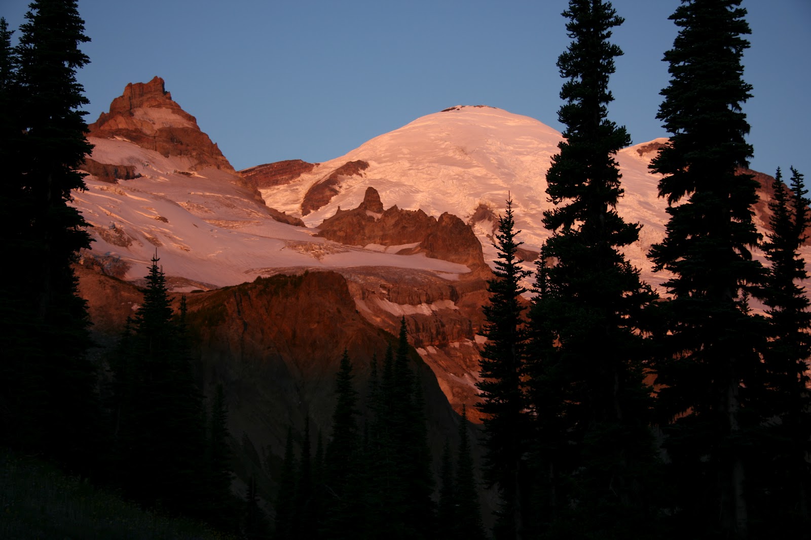
 It looks cold. I was cold!
 |
| First frame of a short celebration video in Summerland camp |
Awoke before sunrise & shot photographs hand held--ugg:
The Golden hour for photography has plenty of red, pink and orange--I shot a few.
Then I hiked out--ixnay on retracing steps to Indian Bar for 2 more nights. saw Dan--who started with his girlfriend who'd pushed to hike the WT together & who'd dropped out at Sunrise on finding the trail too arduous.
Sign, "White River trailhead 0.1 mi" but missed the other sign nearby that directed me to turn left, walked to TH--backtracked and turned. Another sign, "White River Road 0.1 mi" which I ignored and stayed on trail. All signs are suited for hikers going clockwise. To White River campground where Randy had camped. xch tea & email. Randy repeated what most others had said, that the vast majority of hikers walking the WT travel in clockwise direction--maybe then only about 120 people on the trail at any time, which if true means more than one person per mile of trail. Then the 2000' climb up to Sunrise. Mostly in shade. More sky & sun told of my imminent arrival at Sunrise. Bravo.

To the car. Boots off. Flip flops on. to Longmire to p/u tripod/food/fuel. Burger/fries
Note to self. now what: Next trip? not for awhile. REI for betta headlight(?), betta hiking pants? no, forget the hiking pants, shorts with leg warmers worked well enough. food bag that doesn't absorb water, clothing bag (compression?), sleeping bag stuff bag (compression?), snack bag, garbage bag, dental bag.
Make a new stove wind screen. Mark head sweats on list
GEAR LIST
T neck REI thick Navyt neck REI wool
swim jammers
sleeping socks LL Bean midweight hiker
Backpack REI Flash 62 M
Powerade 1 L bottle
Pyrethrum soak for debugging apparel, pack, tent
water: 1 liters
bug dope stick
arm warmers-wool
leg warmers-wool
fleece hat
neck warmer-windproof
headlamp Tikka MUST HAVE
headlamp spare batteries MUST HAVE
iodine, vit C
map MUST HAVE
modified first aid kit MUST HAVE
toilet paper
gaiters
zip off legs
gloves REI GloMits
Raincoat REI Shuksan Jacket
long bottoms Patagonia capilene
pack towel
jacket 800 fill down
pocket knife MUST HAVE
lip balm (SPF 15+) MUST HAVE
head sweats
Clothing blue stuff sack
TENT Six Moon Designs Lunar Solo
TENT Lunar Solo Tyvek footprint
tent stakes MSR
Sleeping Bag Marmot Hydrogen down 30 deg
Sleeping Pad/Pacific Outdoor Equipment Peak Elite AC
Water container Platypus 60 oz hoser
Water container Powerade 32 oz
fuel, Snow Peak 220 gm can
Ti saucepan/lid EverNew .9L rubberbanded shut
stuff sack for food--waterproof
Camera Canon Rebel xTi w/17-85 mm lens
e-reader
food for trip MUST HAVE
pack towel 9x25
tripod
Umbrella GoLite reflective
Umbrella case
sunscreen cream or stick Neutrogena! (SPF 30+) MUST HAVE
Compass MUST HAVE
Bic lighter
toothbrush/paste, floss
soap & cleaning pad
stove Snow Peak Giga power
Stove Snow Peak Giga Power windscreen--DIY video link
spoon plastic Kenyon
bowl, margarine tub
cup green
trekking poles
whistle/mirror MUST HAVE
iPod Touch
TOTAL Pack Weight with food/water 37.33 lb
Food hits/misses:
Veg chili mix Fant Foods+Beanocurry Lentil mix+Beano needs more spice to pump it up.
Black bean mix+Beano
Black bean soup mix+Beano
Refried bean mix+Beano
Above choices are hit--tho they taste great, but gotta remember to pack the Bean-o or suffer a gas attack
Clif bars--on da go fuel--expensive at ~$1 each, so if you have the time to mix & bake your own, do.
Trader Joe spaghetti--great stuff, break it, cook it, don't drain, add one of da mixes above
Trader Joe quick cook Basmati rice--did not cook completely, b/c it needed to cook by itself before adding one of the mixes above
tortillas---great w p. butter or bean mixtop ramen--fast energy
olive oil--high energy, 125% more calories than carbs or protein, bring at least 1-2 oz per day.
basil--oh yea, w/spagh, olive oil, parmesan, pepper.
pepper--mmm hmm
Cheese Parmesan---ah
Cheese Sharp cheddar--ya
raisins
nuts
dried cranberries
dried apples
salami/pepperoni--yup
peanut butter
Tea bags--Double Bergamot Earl Gray
Coffee packs--Vinacafe from the Capitol Pho store on Harrison next to Wendy's in Olympia. good hit of sugar and caffeine.